 Live Radio
|
|||
The San Francisco Bay is a great natural treasure— The San Francisco Bay Conservation and Development Commission (BCDC) is charged with keeping it safe.In 2010, KRCB is presenting the history and future of our beloved Bay in a new series called “Around the Bay with Will Travis,” who is the executive director of BCDC.
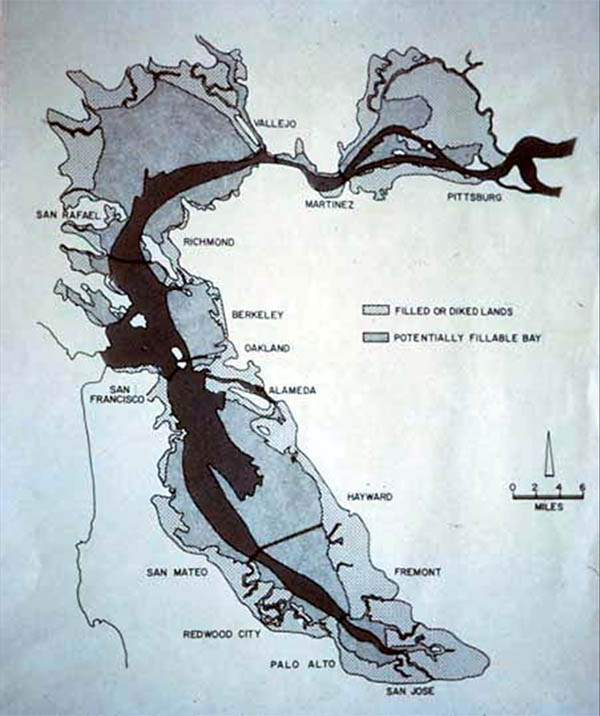
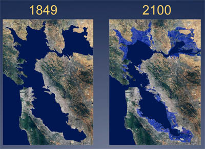
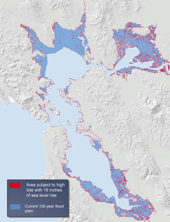
In Episode 1, Will talks about how his agency came into existence, after the public reacted to this 1959 report from the Army Corps of Engineers. In Episode 2, Will addresses how the rising seas have already affected the Bay. This is a chart that illustrates his point.
In Episode 3, Will discusses the importance of levees and wetlands in the protection of our infrastructure.
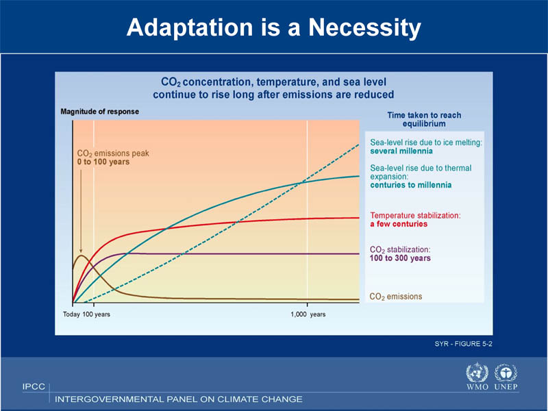
In Episode 4, Will speaks about storms, floods, fires, droughts, and what could happen to our drinking water.
In Episode 5, Will comments on California’s past political leadership and what we can do in the future.
|
|
||


![]()
What can people in poverty do to improve their lives? Mary Gonzales takes an atypical approach; organizing disadvantaged communities to exercise political clout they didn’t know they had.

Mary Gonzales, The Gamalilei Foundation's regional organizer for California and Hawaii, reports that her greatest success story to date occurred in Venturra County, where a combination of organizational outreach and concentrated research enabled the local agricultural community to fend off a major mining operation's plans.
 |
 Photo credit: Paul Bausch
One of the best hikes in Sonoma County, the Pomo Canyon to Shell Beach hike offers a little bit of everything, from towering redwoods to pounding surf, from ferny dells to ridge-top vistas.
TRAILS TO TAKE:
Moderate to strenuous. This gorgeous 6-mile hike offers wildflowers and stunning views of just about every habitat Sonoma County has to offer. At the trailhead, turn right on Pomo Canyon Trail, climbing north through a verdant redwood forest. The trail curves left, climbing up to a wooded ridge before breaking into boulder-strewn grasslands, where the trail turns south and west, crossing small creeks. Cross a fence by a hiker's ladder then climb to a ridge with fantastic views of the Sonoma County coast. The trail soon joins an old road and descends to Highway 1. From there it's a short a quarter mile stroll over the headlands to Shell Beach.
DIRECTIONS: Turn east off Highway 1 at Bridgehaven just south of Russian River bridge onto Willow Creek Road. Drive 2.6 miles, then turn right on Pomo Campground Road and go 0.5 miles to trailhead near campground. The western trailhead is on Highway 1 opposite Shell Beach access road. If you wish to hike only one way, you'll need to take 2 cars and park one at the Shell Beach parking area.
| MAP AND BROCHURE |
| {mosmap kml='http://www.krcb.org/GeocachingNetworkKML.kml'|width='670'|height='400'|address='sonoma coast state Beach Jenner CA'|zoom='15'|zoomType='Large'|zoomNew='0'|mapType='Hybrid'|showMaptype='1'| overview='1'|text='Sonoma Coast State Beach'|tooltip='Sonoma Coast State Beach'|marker='1'| align='center'} |
|
 Photo credit: City of Healdsburg (top) and Nancy Lorenz (bottom right and left)
Throughout this beautiful property you’ll find breathtaking views of the Mayacamas, Fitch Mountain, Lake Sonoma Basin, coastal range and the Russian River. Situated right on the urban edge of Healdsburg, trails wander through oak woodland, serpentine chaparral, and mixed hardwood forests.
TRAILS TO TAKE:
Easy: A short paved hiking trail--remnant of a housing project that never came to be (thank goodness)--runs from the trailhead to Russian River Overlook.
Moderate: We're also fond of the dirt trail veers off on the left from the trailhead, past Fox Pond and up to the Ridge Trail.
DIRECTIONS: From Highway 101, take the Dry Creek exit and go east. Turn left (north) on Healdsburg Avenue and go about 1 mile. Turn right (east) onto Parkland Farms Boulevard and travel to the eastern end of the road (about ¾ miles). Turn right onto Bridle Path and look for on-street parking. Trailhead is at the eastern end of Arabian Way.
| MAP AND BROCHURE |
| {mosmap kml='http://www.krcb.org/GeocachingNetworkKML.kml'|width='670'|height='400'|address='arabian way Healdsburg CA'|zoom='15'|zoomType='Large'|zoomNew='0'|mapType='Hybrid'|showMaptype='1'| overview='1'|text='Healdsburg Ridge Trail'|tooltip='Healdsburg Ridge Trail'|marker='1'| align='center'} |
|
 Photo credit: Carlos Chavez (top and middle) and Bob Dyer (bottom right and left).
Located just outside the Russian River town of Guerneville, this 805-acre park features a magnificent grove of ancient redwoods and a variety of hikes that will take you from ferny redwood groves to oak- and wildflower-studded ridgelines.
TRAILS TO TAKE:
Easy: 1.7 Miles. Take the Pioneer Trail from the park entrance to the Armstrong Tree, then to the picnic area, and return.
Moderate: 2.2 Miles with a 400' climb. Take the East Ridge Trail from the front parking lot to the picnic area and return to the entrance via the Pioneer Trail.
Strenuous: 5.6 Miles with 1100' climb. Take the East Ridge Trail from the front parking lot to the Gilliam Creek trailhead. Loop back down to the Grove by taking the Pool Ridge Trail to the Armstrong Tree. Return to the entrance via the Pioneer Trail.
DIRECTIONS: From Highway 101, take the River Road exit (in Santa Rosa). Go west on River Road until you reach Guerneville. At the second stop light make a right hand turn onto Armstrong Woods Road. This road will end in the park.
| MAP AND BROCHURE |
| {mosmap kml='http://www.krcb.org/GeocachingNetworkKML.kml'|width='670'|height='400'|address='Armstrong Woods Rd Guerneville CA'|zoom='15'|zoomType='Large'|zoomNew='0'|mapType='Hybrid'|showMaptype='1'| overview='1'|text='Armstrong Redwoods State Reserve'|tooltip='Armstrong Redwoods State Reserve'|marker='1'| align='center'} |
