 Live Radio


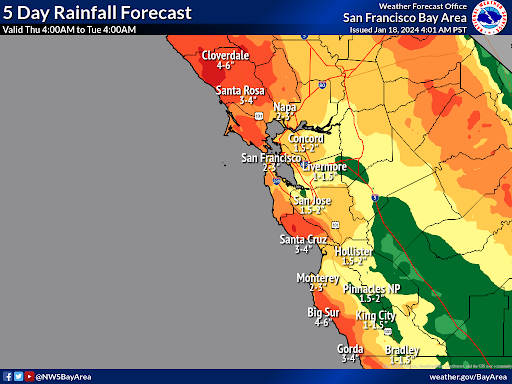 photo credit: National Weather Service via Bay City News
The heaviest rainfall is expected Sunday into Monday,
with some mudslides and minor flooding possible
A series of three back-to-back storm systems will move through the Bay Area over the weekend, dousing the region in rainfall amounts that could lead to minor flooding and landslide risks in some areas.
Almost three inches of rain are expected across low-lying areas of the North Bay and up to seven and a half over the highest north bay mountains. The first band makes landfall Friday evening, with the second storm following close behind on Saturday during the daytime and evening hours, according to the National Weather Service.
Then, after a pause from Saturday night and into Sunday morning, the third system is expected to roll in on a strong jet stream from the Pacific Ocean and will likely produce moderate to heavy rain and gusty southwest winds Sunday afternoon into early Monday.
While major river flooding is unlikely, the estimates could prove fairly inaccurate due to a number of factors.
Mudslides are possible, but major flooding isn't expected locally. According to National Weather Service Meteorologist Rick Canepa, that's largely due to timing.
"If we have this rainfall fall over a greater time period that also is very helpful too, versus seeing rain rates that are like an inch an hour, exceeding an inch an hour," Canepa said.
Although the storms have some signatures of an atmospheric
river, with a trail of warmer moisture stretching west to Hawaii, the main drivers are disturbances out of the Arctic, which will pull that water vapor landward.
Canepa described how the next few days may play out.
"We have a series of systems moving through that will produce moderate, maybe occasionally heavy rain across the North Bay through the weekend. The first rain band arrives this [Friday] afternoon and evening with an initial frontal system pushing through, and then it's kind of off and on showers through the day Saturday and into Sunday and then later, Sunday night into Monday, there will be another focus of moderate to locally heavy rain," Canepa said.
At the same time those systems are converging, Canepa said there are also signs of them splitting, with the bulk of the incoming rain possibly being pushed north or south of us.
According to forecasts available Friday afternoon, the Russian River is expected to remain about five feet below monitor stage and eight feet below flood stage at Guerneville when the river crests there early next week.
According to the California Nevada River Forecast Center, the Russian River is expected to rapidly rise by four feet at Hopland in Mendocino County starting around midnight Monday and exceed flood stage by about a foot for about 12 hours. The base of the bridge carrying State route 175 over the river is expected to be submerged.
While the storms do contain some subtropical moisture, they're not considered a classic atmospheric river, which typically moves more slowly through the region and then stalls out.
The repeated precipitation expected over the next few days will fall on already saturated soils, which could lead to mudslides and downed trees and power lines.
Also, people should be prepared for the rapid rise of rivers and streams along with minor "nuisance" flooding across the region, according to the weather service.
