 Live Radio


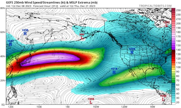 photo credit: tropicaltidbits.com/National Weather Service
A jet stream anomaly could bring strong storms our way
Stormy weather is on the way, with rain likely starting late Sunday and continuing through much of the week.
Forecasters are also keeping an eye on unusual atmospheric conditions that will fuel a series strong, warm storms predicted to begin arriving around Christmas.
The rainy season has been fairly usual so far, and as typical for late December, it's about to go up a notch.
"It does look like there's going to be a, looks like a decent amount of abundant precipitation for much of central and southern California, and then moving into the southwest," said Jon Gottschalck, chief of the operational prediction branch of NOAA's Climate Prediction Center.
"But a little bit later on," Gottschalck continued, "it does look like we're going to be seeing a pretty strong, extended jet stream, across much of the Pacific Ocean as we approach Christmastime."
The jet stream, typically oscillating toward the arctic and tropics as it traverses the Pacific, has recently become unusually straight, a line from near Japan almost to California. That, forecasters say will help storms both form and strengthen.
Currently, forecasts suggest the systems will most impact areas around the Bay and slightly to the north.
"These sorts of events typically could sometimes last for a week or two," Gottschalck said.
The year end-storms should bring another three to six inches to the region, he added.
And that might only be the beginning.
"Some of the things that we're seeing in the upcoming weeks are consistent with that sort of pattern, which is wet for California," Gottschalck said.
A strong El Nino and straight jet stream usually means a wet winter in California, he added.
Just how wet, isn't known yet.
"It's unclear if this will last all winter, meaning multiple, multiple rounds of this, but that certainly is possible with a strong El Nino event from some of the past events that we have observed," Gottschalck said.
