 Live Radio


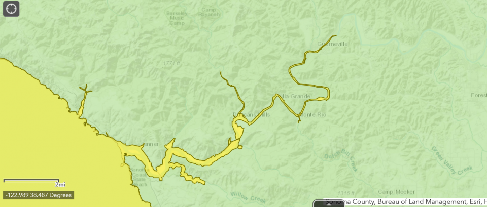 Computer models show a major tsunami pushing ocean water nearly to Guerneville
 photo credit: Courtesy: California Geological Survey
A wall of water walloping Doran Spit. Estero Americano changing course, channeling the pacific upstream, nearly to Valley Ford, water lapping at the edges of the Rocky Memorial Dog Park in Petaluma.
The disaster scenario comes courtesy of the California Geological Survey, which Friday released updated tsunami evacuation maps for many counties, including Sonoma.
Nick Graehl is an engineering geologist with the survey.
"The maximum tsunami flood elevation is about 19 to 26 feet." On much of San Francisco Bay, the same event would produce about a five foot rise, Graehl said.
Caused by certain types of offshore earthquakes displacing huge amounts of water, tsunami's are capable of tremendous devastation. One in 2004 killed a quarter million people, mainly in Asia.
"The most significant tsunami source that could impact the county of Sonoma is from a large magnitude, nine plus, that would originate off the coast of Alaska, and the Aleutian Islands. A Tsunami from this source region, it would take about four hours to arrive in Sonoma, so people would have time to evacuate, if they are prepared."
Severe movement on local fault lines, such as one traversing Point Reyes would be significantly weaker, but Graehl said, local residents would have just minutes to react.
Interactive maps and tsunami preparedness information can be found on the website of the California Department of Conservation or by clicking here https://www.conservation.ca.gov/cgs/tsunami/maps/sonoma.
